As you know, CDD has been analyzing alternative approaches to reducing cumulative traffic growth by adjusting allowable floor-area-ratios (FAR) in commercial and high-density residential zones. We have now completed our analysis of cumulative traffic impacts for five build-out/FAR scenarios. We are still in the process of analyzing other impacts of the FAR scenarios, including impacts on housing, employment, tax base and urban form. This information will be provided at future CGMAC meeting to assist you in evaluating the FAR scenarios.
Previously you have received information regarding the total estimated citywide traffic volumes under each FAR scenario (see memo dated February 2, 2000). We have also provided information illustrating how these trips are distributed by our transportation districts within the city (see February 17, 2000 handout: "Scenario Comparisons"). Attached to this memo is the final piece of our traffic analysis which illustrates the estimated impact of each scenario on the performance of 21 intersections distributed across the city. Below is a summary of the methodology used and the results of the analysis.
Description of the Five Scenarios
In brief, the five scenarios analyzed are:
Each scenario assumes an overall build-out of 33% of its available city wide FAR but assume different build-out in different parts of the city.
One additional scenario is currently being developed. Drawing upon what we have learned from the five scenarios described above, this scenario will make district FAR adjustments which respond to both location (relative to transit and trip generation) and use (relative to trip generation characteristics and planning goals). The traffic impact analysis for this scenario will be provided as soon as it is completed.
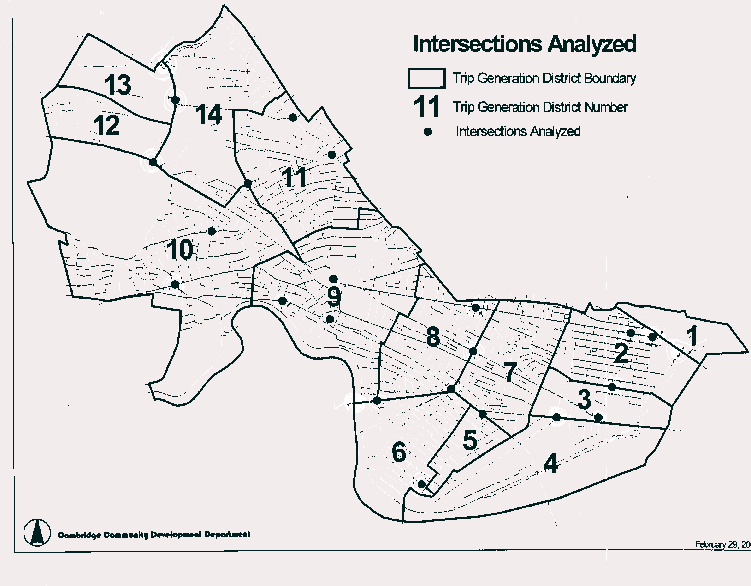
Intersections Analyzed
The 21 intersections analyzed (see map) were chosen based on the following criteria:
Some of the intersections do not meet all of the criteria but were included because of their importance with respect to determining traffic flow patterns within neighborhoods. This, for example, is the case regarding the Fresh Pond Parkway/Concord Avenue Rotary (Sozio).
Methodology Used to Analyze Intersection Performance
Critical Movement Analysis (CMA) was used to estimate how the 21 intersections will operate in the future under each FAR scenario. Critical movement volumes were estimated for the AM and PM peak hours. (see table). The definition of critical movement volume at an intersection is the sum of all conflicting traffic movements expressed in vehicles per hour (see attached graphic for an illustration of "conflicting movements"). Intersections with 1,500 or fewer vehicles per hour and rotaries with 1,800 or fewer vehicles per hour are considered to operate adequately, i.e. motorists will wait no more than two light cycles to get through the intersection. Once these thresholds are exceeded, intersection operation starts to deteriorate exponentially.
Results of the Analysis
We have made a comparative evaluation of intersection performance for the five scenarios using two different methods. The first method (Table A) compares the number of times that either the AM or PM critical movement threshold is exceeded in each scenario (out of 42 possible). The other method (Table B) compares the sum of critical movements above the threshold for each scenario. Both methods are valuable in evaluating the differences between the scenarios.
| Table A - Numberof Threshold Exceedances | ||||
|---|---|---|---|---|
| Existing | Status Quo | 25% FAR Cut | 2x3 Matrix | Housing Incentives |
| 0 | 25 | 14 | 11 | 7 |
| Table B - Summation of Critical Movements Above Threshold | |||||||||
|---|---|---|---|---|---|---|---|---|---|
| Existing | Status Quo | 25% FAR Cut | 2x3 Matrix | Housing Incentives | |||||
| AM | PM | AM | PM | AM | PM | AM | PM | AM | PM |
| 0 | 0 | 2,762 | 4,346 | 1,298 | 1,391 | 767 | 1,053 | 372 | 775 |
Based on this analysis we draw the following conclusions: